Deerfield-News.com-Deerfield Beach,Fl-Lastest update from NOAA and information from The City of Deerfield Beach. Next update 8 pm.
WTNT35 KNHC 012123
TCPAT5

BULLETIN
Hurricane Dorian Advisory Number  34...Corrected
NWS National Hurricane Center Miami FL       AL052019
500 PM EDT Sun Sep 01 2019

Corrected to modify Storm Surge section

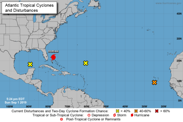
...EYE OF CATASTROPHIC HURRICANE DORIAN CRAWLING OVER THE ABACOS
ISLANDS IN THE BAHAMAS...
...DORIAN'S FURY NOW AIMING TOWARD GRAND BAHAMA...


SUMMARY OF 500 PM EDT...2100 UTC...INFORMATION
----------------------------------------------
LOCATION...26.6N 77.3W
ABOUT 95 MI...150 KM E OF FREEPORT GRAND BAHAMA ISLAND
ABOUT 175 MI...280 KM E OF WEST PALM BEACH FLORIDA
MAXIMUM SUSTAINED WINDS...185 MPH...295 KM/H
PRESENT MOVEMENT...W OR 270 DEGREES AT 5 MPH...7 KM/H
MINIMUM CENTRAL PRESSURE...910 MB...26.88 INCHES


WATCHES AND WARNINGS
--------------------
CHANGES WITH THIS ADVISORY:

A Storm Surge Warning has been issued from Lantana to the
Volusia/Brevard County Line.

A Storm Surge Watch has been issued from the Volusia/Brevard County
Line to the Flagler/Volusia County Line.

A Hurricane Warning has been issued from Jupiter Inlet to the
Volusia/Brevard County Line.

A Hurricane Watch has been issued from the Volusia/Brevard County
Line to the Flagler/Volusia County Line

SUMMARY OF WATCHES AND WARNINGS IN EFFECT:

A Storm Surge Warning is in effect for...
* Lantana to the Volusia/Brevard County Line

A Storm Surge Watch is in effect for...
* North of Deerfield Beach to Lantana
* Volusia/Brevard County Line to the Flagler/Volusia County Line

A Hurricane Warning is in effect for...
* Northwestern Bahamas excluding Andros Island
* Jupiter Inlet to the Volusia/Brevard County Line

A Hurricane Watch is in effect for...
* Andros Island
* North of Deerfield Beach to Jupiter Inlet
* Volusia/Brevard County Line to the Flagler/Volusia County Line

A Tropical Storm Warning is in effect for...
* North of Deerfield Beach to Jupiter Inlet

A Tropical Storm Watch is in effect for...
* North of Golden Beach to Deerfield Beach
* Lake Okeechobee

A Storm Surge Warning means there is a danger of life-threatening
inundation, from rising water moving inland from the coastline,
during the next 36 hours in the indicated locations. For a
depiction of areas at risk, please see the National Weather
Service Storm Surge Watch/Warning Graphic, available at
hurricanes.gov.  This is a life-threatening situation.  Persons
located within these areas should take all necessary actions to
protect life and property from rising water and the potential for
other dangerous conditions.  Promptly follow evacuation and other
instructions from local officials.

A Storm Surge Watch means there is a possibility of life-
threatening inundation, from rising water moving inland from the
coastline, in the indicated locations during the next 48 hours.

A Hurricane Warning means that hurricane conditions are expected
somewhere within the warning area. Preparations to protect life and
property should be rushed to completion.

A Hurricane Watch means that hurricane conditions are possible
within the watch area.  A watch is typically issued 48 hours
before the anticipated first occurrence of tropical-storm-force
winds, conditions that make outside preparations difficult or
dangerous.

A Tropical Storm Warning means that tropical storm conditions are
expected within the warning area within 36 hours.

A Tropical Storm Watch means that tropical storm conditions are
possible within the watch area, generally within 48 hours.

Interests elsewhere along the east coast of Florida should continue
to monitor the progress of Dorian, as additional watches or
warnings may be required later today.

For storm information specific to your area in the United
States, including possible inland watches and warnings, please
monitor products issued by your local National Weather Service
forecast office. For storm information specific to your area
outside of the United States, please monitor products issued by
your national meteorological service.


DISCUSSION AND OUTLOOK
----------------------
At 500 PM EDT (2100 UTC), the distinct eye of Hurricane Dorian was
located near latitude 26.6 North, longitude 77.3 West. Dorian is
moving toward the west near 5 mph (7 km/h). A slower westward
to west-northwestward motions should continue for the next day or
two, followed by a gradual turn toward the northwest.  On this
track, the core of extremely dangerous Hurricane Dorian will
continue to pound Great Abaco this evening and move near or
over Grand Bahama Island tonight and Monday. The hurricane will
move dangerously close to the Florida east coast late Monday through
Tuesday night.

Maximum sustained winds are near 185 mph (295 km/h) with higher
gusts.  Dorian is a category 5 hurricane on the Saffir-Simpson
Hurricane Wind Scale.  Some fluctuations in intensity are likely,
and Dorian is expected to remain a catastrophic hurricane during the
next few days.

Hurricane-force winds extend outward up to 45 miles (75 km) from the
center and tropical-storm-force winds extend outward up to 140 miles
(220 km).

The last minimum central pressure measured by an Air Force
reconnaissance plane a couple of hours ago was 910 mb (26.88
inches).


HAZARDS AFFECTING LAND
----------------------
WIND:  Catastrophic hurricane conditions are occurring in the Abacos
Islands and will spread across Grand Bahama Island tonight. Do not
venture out into the eye, as winds will suddenly increase as the eye
passes.

Hurricane conditions are expected within the hurricane warning area
in Florida by late Monday or Tuesday.

Tropical storm conditions are expected within the tropical storm
warning area on Monday and Tuesday and are possible in the tropical
storm watch area by Monday night.

STORM SURGE:  A life-threatening storm surge will raise water levels
by as much as 18 to 23 feet above normal tide levels in areas of
onshore winds on the Abaco Islands and Grand Bahama Island.  Near
the coast, the surge will be accompanied by large and destructive
waves.

The combination of a dangerous storm surge and the tide will cause
normally dry areas near the coast to be flooded by rising waters
moving inland from the shoreline. The water could reach the
following heights above ground somewhere in the indicated
areas if the peak surge occurs at the time of high tide...

Flagler/Volusia County Line to Lantana FL...4 to 7 ft
North of Deerfield Beach to Lantana FL...2 to 4 ft

The surge will be accompanied by large and destructive waves.
Surge-related flooding depends on the how close the center of
Dorian comes to the Florida east coast, and can vary greatly over
short distances.  For information specific to your area, please see
products issued by your local National Weather Service forecast
office.

RAINFALL:  Dorian is expected to produce the following rainfall
totals through late this week:

Northwestern Bahamas...12 to 24 inches, isolated 30 inches.
Coastal Carolinas...5 to 10 inches, isolated 15 inches.
The Atlantic Coast from the Florida peninsula through Georgia...3 to
6 inches, isolated 9 inches.
Southeastern Virginia...2 to 4 inches, isolated 6 inches.
Central Bahamas...2 to 4 inches, isolated 6 inches.

This rainfall may cause life-threatening flash floods.

SURF:  Large swells are already affecting east-facing shores of the
Bahamas, the Florida east coast, and will spread northward along the
southeastern United States coast during the next few days.  These
swells are likely to cause life-threatening surf and rip current
conditions.  Please consult products from your local weather office.


NEXT ADVISORY
-------------
Next intermediate advisory at 800 PM EDT.
Next complete advisory at 1100 PM EDT.

$$
Forecaster Avila/Cangialosi
Update for Deerfield Beach services being limited or canceled.Tri-Rail service suspended after the last train tonight. There will be no Tri-Rail trains operating on Monday, September 2 and trains will not resume running until further notice.
Garbage Service Suspended!The City received word from our transfer stations they will not be operating tomorrow, therefore all garbage service is suspended for Monday, September 2, 2019. Please remove garbage, recycling, or bulk from curbside. We will issue notice on the status of Tuesday service as soon as possible. We apologize for any inconvenience. Stay safe!
Shelters-
Broward County advises that due to the possibility of power outages, which place special needs residents at risk, they have opened three special needs adults shelters and one pediatric special needs shelter. To register, call the Emergency Hotline at 311 or 954-831-4000. #DFB #DFBPrepares#DFBCares


